| Tai Tun | |
| Distance: 5.0 Km | |
| Duration: 3.0 hours | |
| Diff.: | |
| Scn.: | |
Due to Google changing the terms of Google Map, the daily usage rate will be limited. Please refer to the static map instead if the above map could not be displayed or used normally. I apologize for the inconvenience.
 Static Map
KML file
Tai Tun
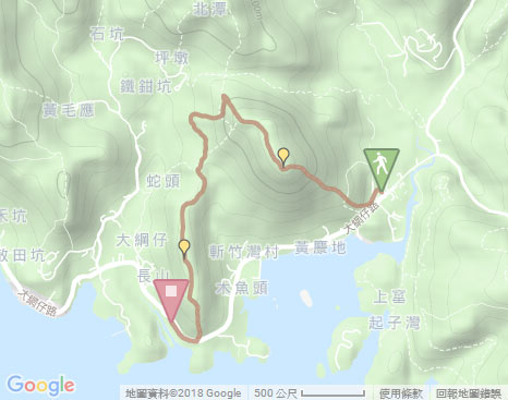
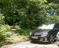
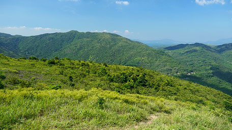
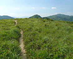
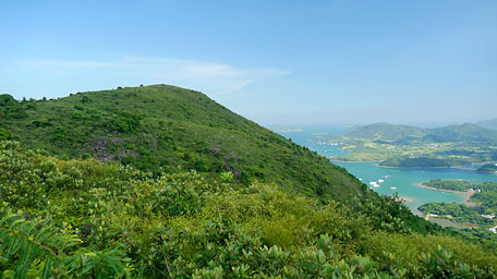
The trail starts by passing through the car park on the left from the refreshment kiosk beside the bus stop of Pak Tam Chung. Head to the end of the car park, it follows the uphill path to climb Tai Tun on the right by the 'P' signpost, which entry has some ribbons as a mark. Along the path, it soon joins the concrete path. Head it a short distance then trace the uphill sylvan path on the right also with the ribbon mark. As the path is steep, you would clamber up. Head the trail, it initially cuts through the woods then opens up at the later leg. Looking up the peak of Tai Tun, it is not high but with mighty aura. In summer, each hill seems to become higher and to be hard to climb. Afterward, ascend to the mid-level, it offers a scenic view over Tsam Chuk Wan. The shallows of the shore skirts along the indented coast and are shading into jade green. Look back far to the right, the undulated rolling hills of Tai Cham Koi and Pai Ngak Shan are within the sight. Futher up, the trail is more steep then becomes gentle and finally leads to the hilltop.
Note: The uphill and downhill paths of Tai Tun are quite steep, it would require to clamber!
Overlooking to the sea southward, it offers a sublime picture that Tai Tau Chau, Kau Sai Chau, Yim Tin Tsai, Sharp Island and the small islands spreading over the sea all are put on a larger green carpet with the shadows of the clouds as decorative patterns. At that time, you could not know you enjoy the spectacular scenery or are sucked into it.
In addition, there are many famous hills all around. At the far east, Sharp Peak exposes its head. Looking far to the north, a splendid green mountain scene could be seen over the ridges of the rolling hills from Lui Ta Shek, Wa Mei Shan undulating up to Shek Uk Shan, like the chain after chain of mountains. The hill of Ngam Tau Shan and the adjacent hill of Ngau Yee Shek Shan are horizontally towering on the right as an embranchment. Moreover, overlooking westward, the lofty Ma On Shan, Wan Cook Shan (as named by hiker) and Pyramid Hill are traceable to the same stock, like a huge dragon with head high toward the sky emitting the mighty aura.
Cheung Shan
Continue on along the trail ahead roughly toward the northwest. Through the woods, it is gently up to the northwest knoll of Tai Tun. At that time, the hill of Lui Ta Shek is just towering at the front. Gazing down on the left, the long and flat hill of Cheung Shan stretches to the coast. Head the trail downhill, it is quite steep. After the sharp descent, it joins the main path of Cheung Shan. Following it to the right could lead to Lui Ta Shek or Pak Tam Chung. Afterward, head the path to the left according to the signpost to the way of Tsam Chuk Wan, it gently cuts through the woods. Beyond the forest, the trail contours along the ridge of Cheung Shan and gradually opens up. Further ahead, it comes to its range pole.
Looking back up, the hill range extending horizontally like a broad screen is Tai Tun just climbed. Afterward continue to head the trail. Before the downhill, it also gives a coast view over Kau Sai Chau. In the sunset, everywhere dye in golden-yellow then guadually fade of colours. The boats and the yachts also return through the channel to reach the shore. Finally, slowly descend the flight of stone steps to Tai Mong Tsai Road.![]()
Branch: After the downhill from Tai Tun, you could follow the path of Cheung Shan to the right leading to Pak Tam Chung as end point.
Related trails : Cheung Sheung | Sharp Peak | Tai Cham Koi
Summary
During the sunny day in summer, air is clear and every tree and grasses are very lush. The mountains look green, the sea water look jade in everywhere of the nature. The hill of Tai Tun is not high, but its hilltop is the best location to overlook Tsam Chuk Wan and Kau Sai Chau.
Last Update : 22.09.2016
Suggestions:
Other Informations:


